
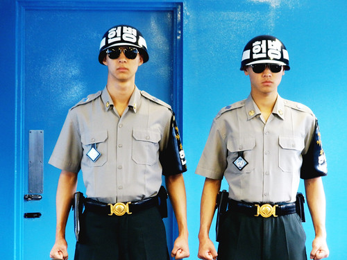
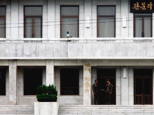
Guards in the Mac Conference Room at the JSA
The point of all this is that I do live very close to the border, and while Mom and Leah were here, we took a trip north to the DMZ. (I had been to the DMZ once before when Sarah visited last summer, but we happened to visit the same Bill Clinton went to North Korea to free the two captured journalists, and halfway through the tour, we were packed into a bus and evacuated due to security concerns.) Our tour started at Camp Bonifas, the United Nations Command military post located a couple hundred meters south of the DMZ. We signed disclaimers telling us that the visit to the Joint Security Area at Panmunjom will entail entry into a hostile area and the possibility of injury or death as a direct result of enemy action, boarded a bus, drove past the most dangerous hole in golf and entered the DMZ. Most people assume that the DMZ is completely isolated, which isn't actually true. The Joint Security Area (JSA) lies within the DMZ, as well as the South Korean town of Daeseong-dong and the North Korean town of Kijong-dong.
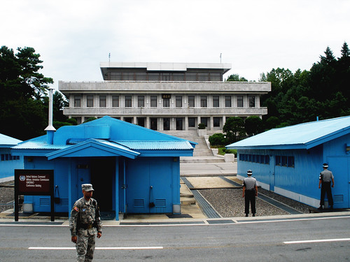
Looking across Conference Row towards North Korea
The first part of the tour visited the JSA. The JSA, with its iconic blue buildings and soldiers staring each other down with clenched fists, is the only official crossing point along the DMZ and the only part of the Korean Peninsula where representatives from the two Koreas meet. We were allowed into the MAC Conference Building, used for talks between North Korea, South Korea and the United Nations Command. The Military Demarcation Line (MDL) runs through the center of the conference building. We were allowed to walk freely through the conference building, meaning I crossed the border into North Korea, if only on a technicality. (The MDL is the actual border between North and South Korea; the DMZ is the 2 km buffer on either side of the MDL.) The next stop was Observation Post #5 for a view of Kijong-dong, the North Korean town located within the DMZ. Kijong-dong is a Potemkin village; it was built by the North Korean in the 1950s for propaganda purposes and the site was never occupied. It is, however, home to the largest flagpole in the world. In the 1970s, the South Korean village of Daeseong-dong, also located within the DMZ, built a new 100m flagpole that was taller than the flagpole in Kijong-dong. The North Koreans responded by erecting a 160 m tall flagpole flying a 600 lb flag at Kijong-dong. The Cold War: two countries getting into a pissing contest over the size of their giant phallic objects.
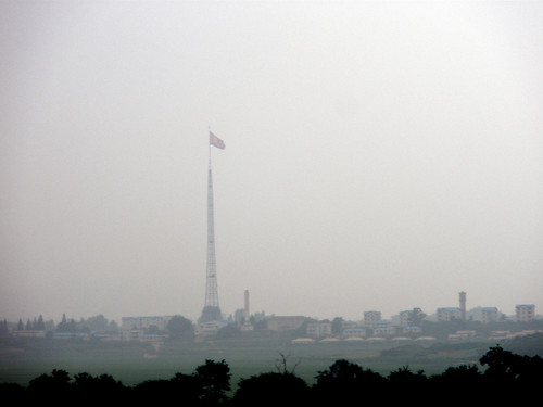
Flagpole at Kijong-dong. Also seen, pollution!
We continued on to the site of the Axe Murder Incident and the Bridge of No Return. On August 18, 1976, North Korean troops attacked a United Nations Command security team guarding a tree trimming detail and axed two American soldiers to death. The UN Command responded with Operation Paul Bunyan, the most expensive tree trimming operation in military history. Arriving in a convoy of twenty three vehicles guarded by two 30-man security platoons from the Joint Security Force and a 64-man ROK special forces company and supported by Cobra attack helicopters, B-52 bombers, F-4 fighters jets, F-5 fighter jets, F-111 fighter jets and the US aircraft carrier Midway, sixteen military engineers chopped the offending poplar tree down with EXTREME PREJUDICE. They trimmed the hell out of that tree. Nearby is the ominous sounding Bridge of No Return, built in 1953 to exchange prisoners at the end of the Korean War.
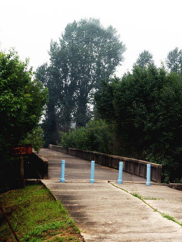
The Cold War blessed the world with both nuclear proliferation and some very dramatic names. Here's the Bridge of No Return.
From there we left the JSA (with a brief stop at the Camp Bonifas gift shop; this might be one of the last outposts of the Cold War, but it's still Korea and I'm just surprised there's not a theme park nearby) and drove to the Third Tunnel of Aggression. The Third Tunnel is the third of four tunnels under the DMZ discovered by South Korea since 1974. The North Koreans have treated the DMZ a little like the obstacles in the children's book We're Going On a Bear Hunt. Uh-uh! A demilitarized zone! A heavily fortified demilitarized zone. We can't go through it. We can't go over it. Oh no! We've got to go under it! Discovered in 1978, the Third Tunnel runs from North Korea into South Korea, is only twenty-seven miles from Seoul and can accommodate 30,000 men per hour along with light weaponry. Now it is a tourist attraction and visitors can don hard hats, descend into the tunnel and walk the two km from the edge of the DMZ to the MDL. The tunnel is low and small and I pity the soldier who has to carry his gear on his back through that tunnel.
The last two stops were the Dora Observatory where, on a clear day (what, we sometimes have clear days in Korea) you can see the North Korean city of Kaesong, and Dorasan Station, the northernmost station on the South Korean side of the Gyeongui Line. One of the oldest railway lines in Korea, the Gyeongui Line originally ran the length of the Korean Peninsula, but has been closed since 1945. It opened briefly from 2007-2008, with freight trains carrying materials to the Kaesong Industrial Region, but closed again after only a year of operation. Dorasan Station, whose motto is "Not the last station from the south, but the first station towards the North," isn't currently serving any trains, but there are signs listing both Seoul and Pyeongyang as destinations.
The trip to the DMZ is a stark reminder of the tension between North and South Korea. The road north from Seoul is lined with barbed wire, guard posts and trenches and during the tour, we were told about the long lists of incidents along the DMZ. Over 500 South Koreans and 50 American soldiers have been killed in skirmishes along the border since the armistice was signed in 1953. It was also a stark reminder of things I don't like to think about. The Seoul area, with a population of twenty-five million people, is just a stone's throw from the North Korean border. Kim Jong-il doesn't need the long-range missiles his country is developing to attack Seoul: short-range missiles from along the DMZ could easily hit the capital, and the sinking of the Cheonan is a clear sign that the dangers aren't all in the past. Something has to give on this peninsula. It's not something I worry about, or even really think about, but every time I hear the air raid sirens or get an email from home, asking what is happening with North Korea, I'm reminded, just for a second, that I live in a country with an emergency evacuation plan.
Just remember: the Norks are always watching.
No comments:
Post a Comment